
Bell Creek is becoming a bit of a nemesis. Not only does it have an ability to call up bad weather forecasts as soon as you mention its name, it’s also the trickiest of all the Mt Wilson canyons to get to.
After two attempts called off due to rain (one a few weeks ago, the other the previous season with Steve Hare), everything seemed to have lined up well for this attempt. Perfect weather and blue skies, a group of 4 consisting of two experienced and two inexperienced canyoners, and a timely start from Mt Wilson. We made good time down the firetrail, found the clear footpad down the ridge, and followed it to the saddle and the Du Faur’s Creek junction easily.
It took us a little while to find the fixed ropes for the descent into Du Faur’s, and the route up the other side. We had a 25m length of static rope as a handline, and I fixed it across the exposed ledge traverse for the others, before leading up the easy slabs above to fix it a second time. From there we headed up the ridge on a rough pad, and skirted around a significant cliffline by heading a long way to the right and finding a short scramble.

From there we headed up a fairly open ridge on a very faint pad to get near to the top of the hill Brennan describes, and started heading west along the top. At this point I pulled out the compass. The going was harder here and there was no real track, although there seemed to be sections with less resistance. At this point I decided we were veering too south, and tried to start following a straight NW bearing. Dropping a little off the top of the ridge we immediately hit much thicker bush.
Things Start To Go Wrong
At this point I got pretty anxious. I was worried we had already taken way to long getting to the canyon. It was very hard to walk in a straight line; there were constant detours around fallen logs and thickets, following the path of least resistance. I had been suffering minor bowel cramps, and this was probably a factor in how clearly I was thinking. I had also underestimated how close we were to the top of the hill, and we were several hundred meters further east than I though we were.
In any case, I thought “fuck it, let’s just go downhill” and convinced myself we were in the NW drainage line into Belfry canyon, after Larissa found a small stream. We continued downhill via heavy, slow creek walking. Often I had to turn around and throw my entire weight backwards into matted vegetation to force a path. I thought we were heading roughly north, and had to end up in Bell Creek one way or another after a few hundred meters.
I was pretty worried though that the creek would enter the canyon via a waterfall. I guess we would have had to follow the rim upstream or downstream, until we found a pass. I was even prepared to lower the others into the canyon via hip/tree belay, before classical abseiling down myself, and leaving the rope behind. As the creek started cutting down through the sandstone layers, we encountered two major waterfalls. The first was jumped and scrambled down via a serious of vegetated ledges on the left, with a little help from the rope. The second was pretty big, and probably the start of the Burramoko sandstone layer, as the creek was cutting a little slot. We were stumped until I scouted over the ridge to the right, and found a perfect pass down about a 4m corner. We set up the handline, descended the corner, stumbled down through some ferns and finally arrived at Bell Creek around 1:30pm after starting at 9am.
Except, the tributary we had followed came in from river left rather than river right…after a few minutes thought and some denial I admitted we were back in Du Faur’s Creek. Looking at the map in hindsight, we had been following the creek at MGA532895.
Oh well. We had a relaxed lunch, changed into wetsuits, and started wading down the pretty creek.
But It Was Not Over
Simon fell significantly behind, and Larissa doubled back to find him. She shortly let out a cry, and with a sinking feeling I joined them to discover Simon had been bitten by a large black spider on his hand.
Shit Shit Shit
“I’m not sure if it’s numb, or if it’s just the freezing water”
We had a first aid kit and EPIRB, of course, and in fact Simon himself was a qualified vet, and helped bandage his own hand. The bite was a bit swollen and sore, but I was reasonably certain it wasn’t a venomous spider or there would have been significantly more screaming. Anyway we decided to calmly make our way downstream to the closest described exit, Joe’s canyon, but activate the beacon in an open section if Simon’s condition began deteriorating.
Du Faur’s Creek Canyon

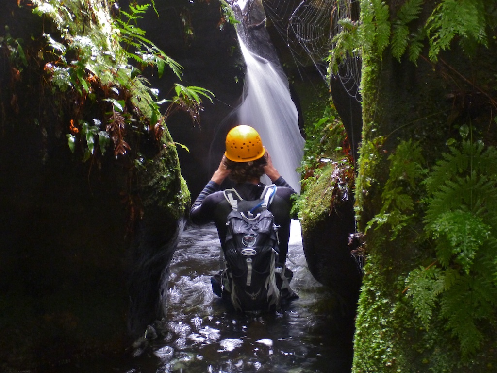
Du Faur’s Creek is a surprisingly pleasant canyon, and even a bit dark and cold at times. There are several canyon sections, and with the higher-than-normal water level the Lilo was actually quite useful for Cathy, who didn’t have the added floatation of a drybag.

Eventually I decided that a side creek entering from the right was Joe’s Canyon. We prepared for the walk out, spent ages deflated the Lilo and everything. But again, I had greatly underestimated the distance we had come: we were moving slow, especially compared to Luke or Bulti whose normal walking speeds outpace many joggers. (Simon was doing OK at this stage). The side creek had little sign of human passage… and ended up in a dead end at a waterfall. Cruelly, I actually recognised the location from one of Dave Noble’s photos where it was described as a small side canyon.
Finally. after back-tracking and continuing down the canyon for another half an hour, we found Joe’s canyon. At this point on the trip my navigational skills had clearly been undermined as I fought an uphill battle to convince everyone that YES THIS IS ACTUALLY THE EXIT I’M SURE THIS TIME FOR REAL.
Joe’s Canyon
The route through Joe’s Canyon is subtle and surprising. It’s a short canyon, but deep, narrow, and winding, and well worth checking out even if you don’t use it as an exit. We got out, walked up the creek, found the exit track (the compass actually helped this time!) and chilled out atop the large pagodas halfway up the Wollongambe 1 entrance track.
Finally after a long and trying day. we made it back to the car.

Conclusion
Simon’s spider was obviously non-venomous, as he drove us back to Sydney and completely forgot he had a bandage on until he wondered aloud what what was smelling like stagnant river water. So the worst casualty of the trip was my poor Wollongambe map which now has a massive rip in it.
I clearly should have listened to Steve when he said the navigation was “a bit tricky”. I later found out that he, Disco and Su Li also got a bit lost trying to find their way into Bell Creek and had a similar experience, although they ended up in the right canyon. They’re an experienced a canyoning party as you could ask for, so that made me feel a bit better. Obviously if you have someone in your party who’s done the canyon before, you’ll avoid getting lost. But I don’t really want to recommend this as we’ve had so much more fun this summer doing canyons ‘onsight’ style, to use the climber’s lingo.
An EPIRB or SPOT beacon, and a first aid kit with a sturdy compression bandage, are really important to bring. At least one headlamp as well. These are things you don’t need at all, until the one day you do, and then you REALLY NEED THEM.
Maps, compass, and track notes as well are so comforting to have. Compasses are pretty hard to use off-track in the Blueys, and with track notes you sometimes get that frustrating feeling that they’re actually more useful if you already know the way. But every little bit helps, especially if you’re trying the canyon onsight as mentioned before, and especially with canyons like Bell Creek and Closet Canyon that require actual navigation and not just following a track.
Well, as proud as I am of our routefinding while off track, the Wollongambe wilderness clearly won this round. Next time, Bell Creek, NEEEXT TIME.

One thought on “Mini-epic debriefing: Bell Creek Canyon attempt 24/2/12”